
by Dr. Tom Johnson (University of York)
I first visited Dunwich in about 2004 on a school trip for Geography. We were, of course, excited to get out of school. It was an usually long journey for a school trip, taking well over an hour from Ipswich. This afforded rich opportunities for messing around on the coach, and the promise, at the end, of a walk on the beach and a lunch of fish and chips.
Yet when we arrived, on a windswept, overcast day, I remember feeling grimly cheated. We had been told we were going to “Dunwich”. I had imagined a small town, like its more famous neighbours of Aldeburgh or Southwold, or at least a village, a settlement; a place in which one could arrive.
Instead, there was nothing. Just a single row of buildings, a short terrace of Victorian coastguard cottages, serving now as a visitor centre and tea shop (and a holiday rental from the National Trust). And thence, for several miles in either direction, nothing but bare sandy heaths, a typically desolate stretch of Suffolk coast.
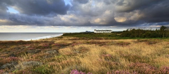
Dunwich Heath, the coastguard cottages visible in the distance (image copyright the National Trust)
I would like to be able to say that I recognized, then, the peculiar kind of loss which had taken place. But in fact, so completely has Dunwich been ground away, that it would take a very keen eye to see that it was not simply an un-place, but an absence. Standing on that scrubby heathland, we were at the prospect point of a vista that no longer existed, overlooking a town that is buried offshore, under the waves.
The last visible hints of such a place had disappeared in the 1950s, when one could still find stray pieces of masonry on the beach. Had some giant dredged these fragments from the sands and reassembled them, it would have made the church of All Saints, glazed with the Perpendicular flint flushwork characteristic of the region (a fine example survives just up the coast at Southwold). It had lain perpendicular to the shore too, its chancel end pointing fatally out to sea.
Having stood in rebuke to the sea for so many centuries, the deterioration of the church was rapid. It is captured in a series of postcards from the late nineteenth and early twentieth centuries. If we trace the process backwards, we can see just a sliver of stonework in 1920 transformed into a grand, recognizable ruin in 1849.
Going back further still, to around 1830, this same structure appears in the background of a painting by J. M. W. Turner, now owned by the Tate. In the foreground, we see the dramatic, wearying rescue of a small boat by its crew, toiling against the overwhelming waves; beyond, perched on the cliffs, we can make out the ghostly ruin of the church, a looming reminder of the sea’s destructive power.

Postcards from 1920, 1919 and 1914 from Jenkins of Southwold. Sketch of 1849 by Hamlet Watling.
Turner was not the first to draw a lesson from the story of the sunken town. In 1754, when All Saints and some other buildings were still standing, the antiquarian Thomas Gardner had published the first history of Dunwich. He suggested that its ‘great and wonderful Decline’, would serve as a good prompt for his readers ‘to ruminate on the Vicissitude, and Instability of sublunary Things’.
For Dunwich had been great once. During the high Middle Ages, it had been one of the most important ports on England’s east coast, home to several thousand people. Its deep, sheltered harbour supported a thriving port; it was an essential source of ships for the king’s navy, and of customs revenue for the royal coffers; and in return, it had a royal charter confirming extensive liberties, an elaborate civic bureaucracy headed by a mayor, and sent two MPs to parliament.
It was, its burgesses claimed in the middle of the fifteenth century, ‘the chief port town to which merchants could repair’ in the region. Yet already by this time, this was a hollow boast rather than a reality. The town had been devastated by a series of natural disasters over the course of the later Middle Ages, and by 1573, it was described by John Dee as a ‘verie little small towne’.
These disasters were threefold. In the first place, gradually taking place over several centuries, the sandy cliffs on which Dunwich had been built were eroded and hauled into the sea – a process clearly underway in the town’s earliest records, and finally completed when the last debris of All Saints fell in the 1920s.
But alongside this slow erosion and subsidence, two rather quicker developments hastened the decline of medieval Dunwich. On one hand, the sheltered anchorage around the estuary of the Dunwich river, lying just north of the town, was gradually clogged with sand carried down the coast by longshore drift (that Geography field-trip was good for something).
On the other hand, there was a series of terrible sea storms in the later thirteenth and early fourteenth century, a product, it is now thought, of an extraordinary climactic adjustment. In 1286-7, 1328, and 1347, Dunwich was inundated by storm surges, which not only destroyed whole neighbourhoods, but drove yet more sand and gravel into the town’s harbour.
Together, these three natural disasters combined to reduce the town’s population, tax-base, and shipping facilities, as well as its influence with the Crown. While the borough limped on through the fourteenth and fifteenth centuries, it increasingly had to contend with the rival claims of smaller settlements nearby – Walberswick and Southwold among them – to act as the main port in the area.
**********************************************
The placelessness of modern Dunwich, its near-complete erasure by the might of the sea, is particularly poignant because this destiny was recognized so early on. The Domesday entry for the town in 1086 noted that the town used to comprise two carucates of land, but recently had only one – ‘the other has been carried off by the sea’.
Its medieval history is full of such plaintive administrative defiance. In 1435, after the burgesses resolved a dispute with one of the neighbouring ports, a new boundary was agreed. It lay at the midway point of the old, silted-up harbour, now a marshy coastal floodplain. But how to preserve a boundary in the face of such turbulence, with the sands still shifting beneath their feet?
It was agreed a tree should be planted to mark the spot. Therefore, ‘in case it should fortune that the old harbour will grow to gravel and stone, as other places by the sea have done, then the tree shall bear record of the true boundary’.
Yet there was still some uncertainty about this. So the burgesses agreed with their neighbours that ‘for more sureness, and to avoid any trouble in case the tree is felled by the rage of the sea or cut down by men, therefore we have measured the ground according to law’. The distance between the old boundary and the new one was 209 rods, roughly a kilometre.
When I came across the legal documents containing these boundary clauses, these two striking images of marking place – planting a tree, and measuring out the distance by rod – stuck with me immediately (and eventually provided me with the title for my article).
They also prompted me to think a great deal about the relationships they were attempting to describe, between a physical place, a living community and its sense of its history, and a set of legal privileges contained in a set of much older royal charters. How did contemporaries understand the relationships between these things? And how should we, as historians, attempt to conceptualize it?
My article, ‘The Tree and the Rod: Jurisdiction in Late-Medieval England’, considers these issues. I argue that we have, perhaps, been too ready to see automatic connections between medieval places and their legal privileges, enshrined as jurisdiction. With cartography, satellite images, barbed-wire and border guards, we moderns conjure pictures of clearly marked-out territory far too easily.
The tools of place-making in the Middle Ages were far less clear-cut, far more contestable. Dunwich provides a wonderful case study for breaking down the connection between place and privilege, as its burgesses continued to insist on their rights, long after the place itself had been transformed beyond recognition from that described in their charters.
Medieval jurisdiction, I argue, did not simply happen. It was the result of a lot of work – very hard work, in the case of Dunwich – in creating a convincing legal interpretation of the relationship between a place, its people, and their rights, and, perhaps even more importantly, communicating that vision effectively to a wide audience, both inside and outside the community.
The eventual failure of that interpretation in Dunwich, the breakdown of the relationship between the physical place and its legal rights, was unlucky. It was the product, of course, of events and processes that lay far beyond the ken of medieval people, let alone their power to prevent them. In the twenty-first century, it is difficult to escape the feeling that we are any different from them. Confronted by the cataclysmic effects of climate changes produced by man-made global warming, we still seem unable to produce any meaningful response.
Yet there is, perhaps, a brighter message to take from Dunwich’s story. Throughout the Middle Ages, running parallel to the town’s continual and apparently inevitable decline, is a history of remarkable human resilience: a determination by its residents to defend against the sea’s destructive impetus, to stake Dunwich’s place on the coast.